ACT-NSW Border Markers and Lockspits
This page last updated 21Oct13. Now at http://www.johnevans.id.au/wp/?page_id=3662
Click any of these links for detailed information and photos: Mouat Line | Johnston Line | Sheaffe Line | Map
|
You can drive past some border markers; others are on the urban fringe. However many are deep in the Bimberi Wilderness of Namadgi National Park. If you are visiting these, please note my Disclaimer, Warning and Advice. |
36 Some clarification from Alex P concerning extra markers we found on the straight line:
"Essentially, every survey mark collinear with the Coree to One Tree line is a, well, line peg. They were placed at a minimum spacing of ten chains (~200 metres) as was the standard requirement for ordinary boundary surveys at the time (still applies). What I gave you was the information I could glean from the two map sheets that covered this stretch of the border. I also got extra information from the relevant field books which showed that other minor marks were also placed. Some of this was a bit tricky due to some distances being only tally marks, which may not have been marked on the ground. Additionally, Percy Sheaffe placed other marks such that anyone standing at one mark could see at least one other mark either side of the mark being occupied. This is what surveyors refer to as intervisibility. I'm not sure what's going on, as the marks that were replaced (that you found) were placed in accordance with the chainages gotten from the original charting. In any case it's not really important, as all the marks between Coree and One Tree are line pegs. These marks apart from delineating the ACT and NSW- only become significant in a legal sense when a surveyor produces a plan of survey that refers to any of these marks."
35 Have spent some time seeking permission to walk on private land from the Dunlop Grasslands Nature Reserve to One Tree Hill, and Mountain Creek Road to the Murrumbidgee River. Most thankful to land owners for their nod.
34 A page of Contributing Walks might help as a bit of an index.
33 In August and September 2012 I did a couple of 'ride and strides', mountain bike riding in from the Mt Clear camping ground car park up along the Clear Range. I'll soon run out of bits of the border which can be reached via day walks.
32 Can I finish off the ACT border in 2013, the Centenary of Canberra year? I hear that the SES folk are interested in doing it (talk to me, guys!). So is Derek S of BBC.
31 Mike Lavis reports on resurveying the straight line that "Ian Rose did from Coree to the 6 Mile mark (near Two Sticks Road), I did from the 6M to the 12M (at Parkwood Road), Chris Ablett did the next few miles, and Ian Rose did the last bit up to One Tree."
30 On 6 Mar 12 and 13 Mar 12 I did a couple of trips near Two Sticks Hill on the straight line of the border between Mt Coree and One Tree Hill. Border markers (not corners, of course, but chainage markers at various numbers of links from Mt Coree) were found and Alex Petrow from ACTPLA was kind enough to supply location data and set me running in the right direction. A whole new area of the border to explore!
29 During Feb-Mar 11 I spent some time contacting the Sporting Shooters Association of Australia to get their in principle nod to go up the back of their range on an agreed day. The next area was the Majura field firing range and it proved difficult to find a Defence contact. But walking with Monika B on 15 Mar 11 down the other end of the ACT I mentioned this next little project and she produced a wonderfully cooperative contact living in Goldmines Rd in NSW, to the N of the border area. Joanna P did a huge amount of organising access permissions with her friends and neighbours on the NSW side of the border and with these, SSAA and Majura Range nods, we went through the area on 10 May 11.
28 Although this is not border marker stuff, Alex Petrow from ACTPLA once again helped me with geomin ![]() input formatting. In this instance, it's locations specified in Tidbinbilla Nature Reserve Cultural Resource Survey and Conservation Palm 20 May 1991 by David Bulbeck and Philip Boot. They are described as eg. "The grid reference for the homestead is AC 1:10k Planning Series Map 192-588, 192.39e 588.28n." "These should be input as 192390 for the easting and 588280 for the northing", says Alex, because "With Geomin (and any co-ordinate transformation program) you’ve got to put in the full co-ordinates, not some abbreviated map-reading format." Thanks mate!
input formatting. In this instance, it's locations specified in Tidbinbilla Nature Reserve Cultural Resource Survey and Conservation Palm 20 May 1991 by David Bulbeck and Philip Boot. They are described as eg. "The grid reference for the homestead is AC 1:10k Planning Series Map 192-588, 192.39e 588.28n." "These should be input as 192390 for the easting and 588280 for the northing", says Alex, because "With Geomin (and any co-ordinate transformation program) you’ve got to put in the full co-ordinates, not some abbreviated map-reading format." Thanks mate!
27 Winners of the 'Show Us Your Limits' photo competition announced on 1 Dec 10. See http://www.canberra100.com.au/show-us-your-limit/ for the fabulous results. Sadly, my mates and I didn't win a prize (grin).
26 I did a presentation to the U3A Australian History Group on 9 Nov 10. Met the ACT Surveyor-General who retired in 2000.
25 Border markers on the N Clear Range (N of NNP) also need to be accessed through private property. Gain permission prior to walking on someone's land.
24 I did a presentation to the ACT Regional Studies network at lunchtime on 20 Oct 10. A wonderfully receptive group. Met the granddaughter of Mouat!
23 The final Centenary of Canberra 'Show Us Your Limits' Talk and Walk was on Saturday 21 August (after you've voted). Details here.
22 Another Talk and Walk to border marker X4 in Goorooyarroo Nature Reserve on 10 Jul 10, with Alex Petrow (Registrar to the ACT Surveyor-General) as guest speaker. A great write-up of it here.
21 The CBC Tuesday walk on 25 May 10 witnessed the positioning of a plaque on Mt Coree to commemorate the ACT border survey. Official guests were the Governor of NSW, Marie Bashir, the ACT Chief Minister, Jon Stanhope, the Surveyors-General of NSW and the ACT and descendents of the original surveyors. I guess we attended as uninvited (but not unwelcomed) rubber-neckers. The border runs through the middle of the plaque and nearby temporary border markers were set up to indicate this:
 |
 |
20 Please note: Border markers between One Tree Hill and Mulligans Flat Nature Reserve in the NW of the ACT (One Tree to B2) can only be accessed via ACT leasehold/NSW freehold land. I'm sure some other areas that I have not yet visited are also. How would you like to have a stranger frigging about in your backyard? So gain permission before entering any private land.
19 An excellent Talk and Walk with Matthew Higgins at Mt Franklin on 2 May 10. A participant was Peter P, the Place Names Officer at ACTPLA. Afterwards, he kindly provided the link http://www.legislation.act.gov.au/di/2010-50/current/pdf/2010-50.pdf to recent legislation which names the parts of the ACT border after the surveyors who defined it - the Sheaffe, Mouat and Johnston Lines:
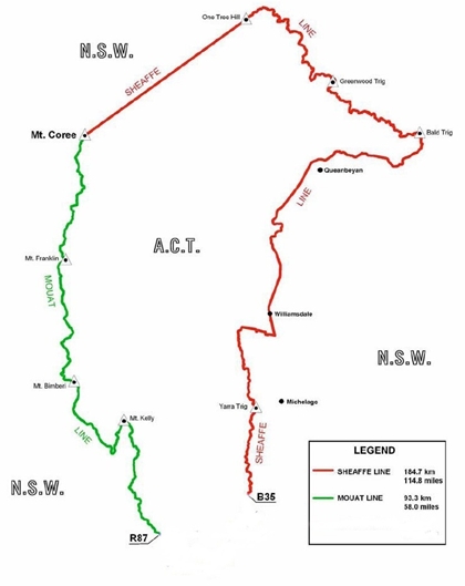
Sheaffe Line - In June 1910 Percy Lempriere Sheaffe started surveying the ACT/NSW border from Coree Trigonometrical Station. His first 31km took him in a straight line to One Tree Trig Station, across some very rugged terrain. From there he followed the northern catchment ridges of the Molonglo River, the Goulburn-Cooma railway and the Clear Range to Corner B35.
Mouat Line - On 7th October 1913, Harry Playfair Mouat began surveying southward from Mt Coree along the ranges dividing the Cotter and Goodradigbee catchments. In many places he had to use steel pipes or spikes as border markers due to the rocky terrain. He finished his work at Corner R87 on 22nd April 1915.
Johnston Line - On 1st March 1915, Frederick Marshall Johnston took over Sheaffe’s work and continued along the Clear Range southward and then westward to the Boboyan Divide, reaching Mouat's R87 corner mark on 28th May 1915.
18 Les G from the NSW Lands and Management Authority notes that all Commonwealth surveys were marked using a Broad Arrow with a bar below the arrow, whilst there was no bar below the arrow for State surveys. He also provided the fact that all actual measurements involving the blaze (eg. distance and direction to the corner marker) werere taken from the tip of the broad arrow.
17 With 2010 being the centenary of (the
commencement) of the ACT border surveys, projects are afoot to celebrate the
work. Daniel W, the Community Engagement Officer, Centenary of Canberra, Chief Minister's Department of the ACT Government (also hang glider!) is pulling it all together. Yay - I'm vindicated! See www.canberra100.com.au ![]() , particularly the Centanary of Canberra Launch Multimedia Competition
, particularly the Centanary of Canberra Launch Multimedia Competition ![]() and the 'Show Us Your Limits'
and the 'Show Us Your Limits' ![]() competition. In general, there are opportunities here - to get people out enjoying the bush and our heritage (natural, indigenous and human placed) - media exposure, border walking tracks, books.
competition. In general, there are opportunities here - to get people out enjoying the bush and our heritage (natural, indigenous and human placed) - media exposure, border walking tracks, books.
16 Natalie M, the ranger managing Brindabella National Park and the NSW Bimberi Wilderness area, tells me (Jan 10) that there is an ACT proposal to mount a plaque on M Coree to commemorate the centenary of the commencement of the survey of the ACT.
15 Alex P was the perfect Santa - a presso of all the border marker locations arrived on 23 Dec 09!
14 On survey marks, Alex P (guru of border markers), provided: 'In NSW (and the ACT) the bearing from a reference mark –such as a tree with a shield (“blaze”) cut into it- the bearing was always from the reference mark to the corner. Occasionally a Qld surveyor might have done the survey and showed the reverse bearing (bearing from the tree to the corner + or – 180 degrees), or the surveyor inadvertently showed the reverse bearing on the plan.'
13 The Confederation of Bushwalking Clubs NSW has been kind enough to publish my article on ACT-NSW
Border Markers in the Winter 2009 edition of its magazine The Bushwalker (2.8Mb to download from here ![]() ).
).
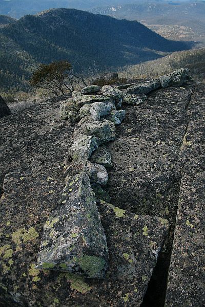
12 A great new contact from Les G in September 09 from NSW Lands. His contribution to 11 below when I questioned him was 'rock lockspits' = 'rockspits'! We (NSW & ACT) have recently re-surveyed part of the ACT-NSW border after the devastating bush fires and some of those new marks are what you have photographed. Basically we re-surveyed from Coree to Ginini plus the straight bit from Coree to One Tree. NSW provided the Survey Control for the job and ACT contracted the cadastral survey work to actually re-place the pegs and rockspits. Hence some of the marks are new marks and some are very old.
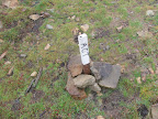
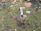
11 More excellent information from Alex P in July 09 cleared up one small issue. "These stone “markers” are not really corner markers as such; they are more an aid in finding a corner. The survey practice directions mention that these lockspits are to be trenches dug about 1.5 metres long, 200mm wide and 150mm deep, to be dug in the direction of all boundary lines running into (or out of) the corner where the peg (marker) is located. As an alternative, a surveyor can make a similar feature out “…of packed stones of similar dimensions.” The correct term is “lockspit”. Unfortunately, (to me anyway!) “lock” rhymes with “rock”. Stones are “rocks”, so...”rockspits” [is an incorrect term]. The term is really a form of argot, though I'd regard it as rhyming slang. Some surveyors use the term to describe any lockspit made from packed-together stones/rocks. The various survey practice directions and survey regulations issued by state governments refer to the features as either “lockspits” or “trenches”, never “rockspits”."
10 In June 2009 Matthew Higgins spoke at the CBC monthly meeting about his new book Rugged Beyond Imagination - Stories from an Australian mountain region, Matthew Higgins, National Museum of Australia Press Canberra 2009. Matthew is the guru of all things Namadgi (and beyond) and I met with him a few days later. He directed me to various of his source material including, for border markers, Surveyors at the Snowline - Surveying the ACT-NSW Border 1910-1915 Matthew Higgins, National Trust 1996. This is held by the National Trust (ACT) and permission was given for me to have a squiz at it. Absolutely wonderful! I spent a few hours taking notes, only to realise back at home that the Survey Site Number and GR from Matthew's field work are the source for the Heritage Register Site No and Heritage Register Location below. Still, there were other useful comments (as well as the marvelous background reading) and it was great to see photos of the 8" posts and many of the reference tree blazes. The 2003 fires obviously were disastrous. Matthew did his field work in the mid to late 1990s. The fires, and improved GPS technology and access to the ACTPLA locations, have allowed additional border markers to be found since then (those below with Heritage Register Site No and Location = -.
9 Data as at May 2009 - After many hours of RSI-inducing work, I've
manipulated the source data into 741 Border Marker locations stretching from Mt
Coree to Y40 which is east of the Boboyan Road towards Burnt Hill in the
southern ACT. You can have it if you want, in any of the various forms. The best
would be OziExplorer waypoints which have been exported to a text file. Of
course I'll give you the record format so you can manipulate in Excel. There's a
freeware utility GPSBabel ![]() which will
convert between various GPS formats. In return, you can sponsor me in the Walk for Uganda, minimum
50cents/km.
which will
convert between various GPS formats. In return, you can sponsor me in the Walk for Uganda, minimum
50cents/km.
8 Another source of information came to hand from Terence U in April 09. He loaned me 4 A0 sized map drawings dated 29/4/44 which he'd gained from Matthew H, the master of all things in Namadgi. This was obviously a re-survey of the border. The maps cover border markers Y40 to H82. I had to consult Alex P again to help me convert the
So, to convert one of these puppies, let's try Y40 319396.52 South, 7750.58
West. Convert to East and North: -7750.58, East, -319396.52 North.
Convert the links to metres: -7750.58*0.3047963853*0.66=-1559.15 East,
-319396.52*0.3047963853*0.66=-64251.60
North. Adjust for Mt Stromlo origin: -1559.15+200,000=198440.84 E,
-64251.60+600,000=535748.40 N. Plug into the conversion routine geomin ![]() which returns 679894.96 E, 6025837.76 N. This can be used as UTM
WGS84≈MGA94
coordinates for OziExplorer plotting and feeding to the GPS.
which returns 679894.96 E, 6025837.76 N. This can be used as UTM
WGS84≈MGA94
coordinates for OziExplorer plotting and feeding to the GPS.
7 Other useful information that Alex P provided
Alex is cool - I love his technospeak (just joking, technical terms avoid confusion). Further info is:
6 I thought it would be relatively easy to begin with the border markers around Pryors Hut, but comparisons from the two lists were just not consistent. So I called on my ACTPLA guru contact, Alex P, who set me running by telling me that the angled border marker ~150m S of Pryors Hut is Q57, not P57. With this start point, additional information kindly provided in the form of MGA UTM locations (to the thousandth of a metre!) for Coree to S81 and detailed analysis of the original survey, I was away and running.
5 So here was the opportunity to meld together three sources of information so as to enhance the enjoyment of future walks touching the border - the ACT Heritage Register List, the ACTPLA original survey material and my photos, walk descriptions and locations. This little project is perhaps in proportion to Rob H, Karen C and others' epic cairn hunting along the Black-Allen line (the straight NSW-Vic border) in 2008 - their trip was hundreds of kilometres and the cairns above head height; my day trips mere tens of kilometres and cairns to the height of one's shins.
4 The original border survey was completed during the period 1910-1915. I've not managed to find one of the many original 8" Posts or nearby survey marks blazed on trees (no doubt burnt/died). There appear to have been any number of re-surveys:
3 In March 09 Peter D contacted me via my blog and
we met for a coffee. Thanks to his tenacious sleuthing he shared with me the
fact that the ACT Planning and Land Authority have made available digitally the
ACT/NSW border survey original field books. They can be found here ![]() .
.
2 With an increasing interest in the sites
described in the Sites of Significance in the ACT and other evidence of
land occupation and use (both indigenous and non-indigenous) I trawled the ACT
Heritage Register site and came up with their entry for the ACT-NSW border
markers. It can be found here ![]() . At the same time an ever increasing number of cairns marking the
border were seen on my various wanderings.
. At the same time an ever increasing number of cairns marking the
border were seen on my various wanderings.
1 I can't remember when I first became interested
in the ACT-NSW border markers. The first time I saw one was on 19 Jan 05. Of course the
Western border of the ACT is the most interesting and rugged and it's along here
that the majority of them were placed when the ACT border was originally
surveyed, primarily to define our water catchment. A history of the original
ACT-NSW border survey can be found here ![]() .
.
The Mouat Line - for descriptions, locations and photographs of bordermarkers, lockspits, carins, mile markers and blazes, click here
Map from Public Place Names (Australian Capital Territory) Determination 2010 (No 1) at
http://www.legislation.act.gov.au/di/2010-50/current/pdf/2010-50.pdf
The Johnston Line - for descriptions, locations and photographs of bordermarkers, lockspits, carins, mile markers and blazes, click here
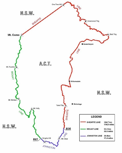
Map from Public Place Names (Australian Capital Territory) Determination 2010 (No 1) at http://www.legislation.act.gov.au/di/2010-50/current/pdf/2010-50.pdf
The Sheaffe Line - for descriptions, locations and photographs of bordermarkers, lockspits, carins, mile markers and blazes, click here
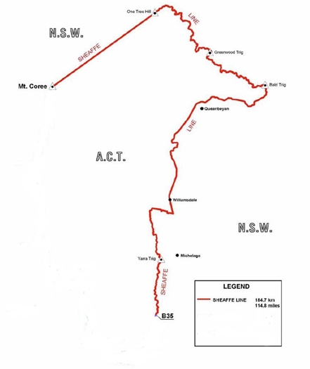
Map from Public Place Names (Australian Capital Territory) Determination 2010 (No 1) at http://www.legislation.act.gov.au/di/2010-50/current/pdf/2010-50.pdf
Explanatory Notes
3 Surveyors at the Snowline - Surveying the ACT-NSW Border 1910-1915 Matthew Higgins, National Trust 1996.
4 See my Map Reading and Navigation page for information on the UTM coordinate system.
5 Many of the original corner markers, particularly the 8" Posts, are no longer extant.
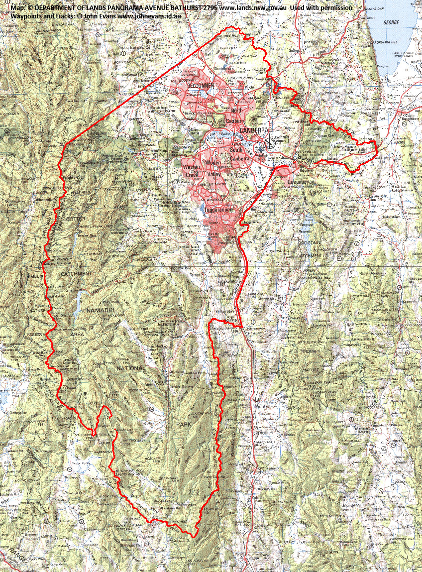
Here's an image of the bits of the border I've found border markers on (current to 22 Mar 14):
Back to Walks Index